Machame Route: The Scenic Ascent to Kilimanjaro’s Summit
Machame Route Of Mount Kilimanjaro, often referred to as the “Whiskey Route,” is renowned for its scenic beauty and challenging terrain. Mount Kilimanjaro, standing tall as the highest peak in Africa, draws adventurers from around the globe.Here’s a comprehensive guide to what makes the Machame Route a popular and rewarding choice for climbers.
Overview of the Machame Route
- Nickname: Whiskey Route
- Duration: 6-7 days
- Distance: Approximately 62 kilometers (38.5 miles) round trip
- Elevation: Starts at 1,640 meters (5,380 feet) and reaches 5,895 meters (19,341 feet) at the summit
- Accommodation: Tents
Key Features Of Machame Route Of Mount Kilimanjaro
Accommodation: Unlike the Marangu Route, which offers hut accommodations, the Machame Route requires camping. Climbers sleep in tents, which are set up by support staff. This adds a sense of adventure but also requires more preparation and equipment.
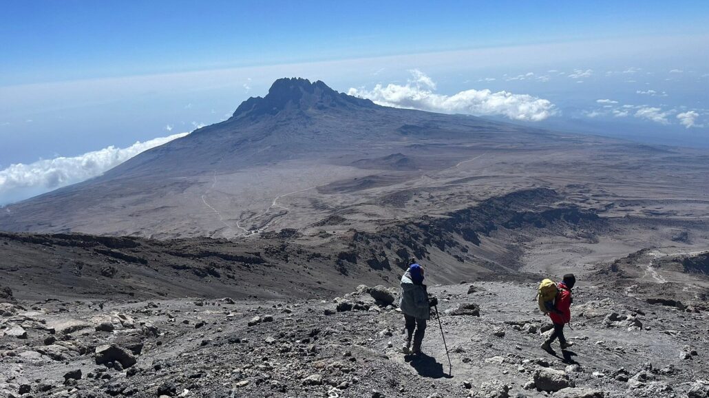
Terrain: The Machame Route is known for its challenging and varied terrain. It offers steep sections, rocky paths, and some scrambling. The route’s diverse landscapes include lush rainforests, heath, moorland, and alpine desert, providing a rich visual experience.
Scenery: This route is celebrated for its stunning and varied scenery. Climbers traverse through dense forests, cross picturesque valleys, and ascend along ridges with panoramic views of the landscape below and the peak above. The scenic diversity makes each day of the trek unique and memorable.
Day-by-Day Itinerary Of The 7 Days Kilimanjaro Machame Route Trek
Day 1: Machame Gate to Machame Camp
- Distance: 11 km (7 miles)
- Elevation Gain: 1,220 meters (4,000 feet)
- Duration: 5-7 hours
- Starting Elevation: 1,640 meters (5,380 feet)
- Ending Elevation: 2,860 meters (9,383 feet)
- Description: The trek begins at Machame Gate, leading through the lush montane forest. This initial stage is marked by a well-defined path and abundant wildlife. The day ends at Machame Camp.
Day 2: Machame Camp to Shira Camp
- Distance: 5 km (3 miles)
- Elevation Gain: 850 meters (2,800 feet)
- Duration: 4-6 hours
- Starting Elevation: 2,860 meters (9,383 feet)
- Ending Elevation: 3,720 meters (12,205 feet)
- Description: The trail continues through the forest before ascending into the moorland zone. The path becomes steeper, and the landscape opens up, offering views of the peak. Shira Camp is located on the Shira Plateau, a high-altitude desert.
Day 3: Shira Camp to Lava Tower to Barranco Camp
- Distance: 10 km (6 miles) to Lava Tower, then 4 km (2.5 miles) to Barranco Camp
- Elevation Gain: 740 meters (2,428 feet) to Lava Tower, then descent of 650 meters (2,133 feet) to Barranco Camp
- Duration: 6-8 hours
- Starting Elevation: 3,720 meters (12,205 feet)
- Highest Elevation: 4,630 meters (15,190 feet) at Lava Tower
- Ending Elevation: 3,950 meters (12,960 feet)
- Description: This acclimatization day involves hiking up to the Lava Tower before descending to Barranco Camp. This “climb high, sleep low” strategy helps with acclimatization. The route passes through the alpine desert zone, characterized by sparse vegetation and rugged terrain.
Day 4: Barranco Camp to Karanga Camp
-
- Distance: 5 km (3 miles)
- Elevation Gain: 260 meters (853 feet)
- Elevation Loss: 280 meters (919 feet)
- Duration: 4-5 hours
- Starting Elevation: 3,950 meters (12,960 feet)
- Ending Elevation: 4,200 meters (13,780 feet)
- Description: This stage includes the challenging Barranco Wall, a steep rock face that requires some scrambling. Once over the wall, the path descends into the Karanga Valley and then ascends to Karanga Camp. The day’s trek offers dramatic views and a sense of achievement.
Day 5: Karanga Camp to Barafu Camp
- Distance: 4 km (2.5 miles)
- Elevation Gain: 600 meters (1,968 feet)
- Duration: 4-5 hours
- Starting Elevation: 4,200 meters (13,780 feet)
- Ending Elevation: 4,800 meters (15,750 feet)
- Description: The trail continues through the alpine desert, with a steady climb to Barafu Camp. This camp serves as the base camp for the final summit push. Climbers rest here before the midnight ascent to Uhuru Peak.
Day 6: Barafu Camp to Uhuru Peak to Mweka Camp
- Distance: 5 km (3.1 miles) ascent + 12 km (7.5 miles) descent
- Elevation Gain: 1,095 meters (3,590 feet)
- Elevation Loss: 2,795 meters (9,170 feet)
- Duration: 6-8 hours to Uhuru Peak, then 5-7 hours to Mweka Camp
- Starting Elevation: 4,800 meters (15,750 feet)
- Summit Elevation: 5,895 meters (19,341 feet)
- Ending Elevation: 3,100 meters (10,170 feet)
- Description: The final ascent begins around midnight, with a steep climb to Stella Point and then along the crater rim to Uhuru Peak, the highest point in Africa. After celebrating the summit, climbers descend back to Barafu Camp for a short rest, then continue down to Mweka Camp for the night.
Day 7: Mweka Camp to Mweka Gate
- Distance: 10 km (6.2 miles)
- Elevation Loss: 1,400 meters (4,593 feet)
- Duration: 3-4 hours
- Starting Elevation: 3,100 meters (10,170 feet)
- Ending Elevation: 1,700 meters (5,577 feet)
- Description: The final day involves a descent through the rainforest to Mweka Gate, where climbers receive their summit certificates. The lush surroundings and easier descent provide a relaxing end to the trek.
Pros and Cons
Pros:
- Scenic Diversity: Offers some of the most varied and beautiful landscapes on Kilimanjaro.
- Higher Success Rate: The longer duration and acclimatization days increase the chance of reaching the summit.
- Adventure: The camping experience and challenging terrain provide a sense of adventure and achievement.
Cons:
- Physically Demanding: The steep sections and longer days can be challenging, requiring good physical fitness.
- Camping Required: Requires more gear and preparation compared to routes with hut accommodations.
- Crowded: Can be busy, especially during peak climbing seasons.
Preparation Tips
- Physical Fitness: Engage in regular exercise, including cardiovascular and strength training, to prepare for the trek.
- Acclimatization: Consider additional days for acclimatization and follow the “climb high, sleep low” principle.
- Gear: Ensure you have proper clothing, sturdy hiking boots, and gear for cold weather and camping.
- Hydration and Nutrition: Drink plenty of water and eat a balanced diet to support your body during the climb.